Following are responses to questions received via email AND at the Bretton Ridge storm follow-up meeting on June 16, 2020 with Mayor Kennedy…the questions have been answered by the city engineer and his team.
Particularly of note here are the questions about drainage and flow around the new Vitalia Senior Living project on Lorain Rd. Many residents of the north side of Bretton Ridge, particularly at the north end of the development question whether the construction project has affected the flooding in their property, the street or yards. This discussion is ongoing. Please see the responses about flow and retention below.
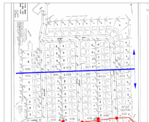
It is important to note that the majority of the stormwater system in Bretton Ridge flows south then east toward a main line connection that connects to the drainage along I-480, and NOT north up to the park then east down Root Ditch. Only a small minority of homes along Stewart Drive, Christman, Stafford and Somerset flow NORTH to the park drain, and then into the Root Ditch. This flow separation is indicated on the map provided by the city here attached to this post. Note the blue line and arrows on the right side of the map.
The following are some questions asked via email and in person specifically regarding drainage in Bretton Ridge AND how the storm and sanitary systems might be affected by the new Vitalia Senior Living construction project. These questions are separated into parts to address the two water systems; storm and sanitary for coherence. Bold text are questions, regular text following are answers from the city engineering department.
SANITARY AND GENERAL
- How many beds are planned for this facility? The development includes approximately 40 2‐bedroom and 57 1‐bedroom independent senior living units and 64 1‐bedroom assisted senior living units.
- Does all sanitary effluent pass through the 8” sanitary grinder and move away from Bretton Ridge? All sanitary effluent from the development passes through a grinder before connecting to the city system.
- If not, what flows toward/through the Bretton Ridge Sanitary System? All sanitary effluent from the Omni development is collected by the city system and enters Bretton Ridge at the Brighton Dr. cul‐de‐sac.
- If any of this flows through the Bretton Ridge line, what is the size(s) of the sanitary line for Bretton Ridge and is this sufficient to handle the 8” pipe from Omni and the number of residents at peak demand after meals? See attached city sanitary sewer map.
STORM SYSTEM
- What is the capacity of the Bretton Ridge storm sewer lines to handle the increased impervious surface from Omni? Can they handle 5 inches of rain in a 24 hour period with water flowing out of the 36” line serving Omni Senior Living North Olmsted? The capacity of storm sewers depends on diameter, slope, material, and alignment, therefore varies based on location. 5 inches of rain in 24 hours is not the local standard for storm sewer design, and the Omni site doesn’t discharge that amount, nor does it enter the main storm sewer trunk line that bisects Bretton Ridge in line with Cambridge Drive, therefore I don’t understand the question. Please clarify further. *This question was not clarified further.
- Why isn’t there a connection to the storm sewer line on Lorain Rd which the project fronts on. There is no storm sewer main in Lorain Rd along the frontage of the Omni/Vitalia property. The nearest available storm sewer in Lorain is located at the intersection of Lorain and Christman.
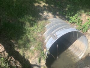
- Does the Omni project storm sewer connect to the Chrisman Drive storm sewer? If so, why? Yes, the developer installed a new storm pipe from the Omni/Vitalia site to the catch basin in Christman Dr., then replaced the storm pipe from Christman Dr. to Root Ditch with a larger pipe. The larger pipe was sized to handle flow from the Omni/Vitalia site as well as provide additional capacity to address previously known street ponding issues in this portion of Christman Dr.
- Does the Christman Drive storm sewer connect to the Lorain Road storm sewer? No, see response to #2 above.
- Does the water in Christman Drive sewer flow north or south? Storm water runoff in this section of Christman Rd flows south from Lorain, and north from Stewart Dr., to catch basins located at a low point at the HOA drive apron.
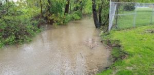
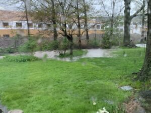
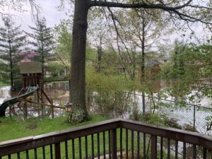
- Where does the Omni project storm water flow once it enters the ditch adjacent to Bretton Ridge Park? Is the ditch just a retention basin to delay the flow through Bretton Ridge? Root Ditch is a natural drainage way that runs parallel with Lorain Rd from Christman Dr to Decker Dr, before it bends south and travels through the High School property and Springvale Golf Course before connecting with the Rocky River. Between Christman and Decker, Root Ditch crosses Stearns Rd, Park Ridge Dr., Mackenzie Rd via underground culverts. Water in Root Ditch did not appear to be flowing during the storm because the ditch was full from the extreme rain event. However the water level in the ditch receded once the rain stopped.
- What is the Route that the storm water from Bretton Ridge takes to get to the Rocky River? Most of Bretton Ridge enters a storm sewer trunk line that bisects the subdivision in line with Cambridge Dr. in the east-west direction (see attached map). It then crosses Stearns Rd and discharges into a natural open channel located south of Windsor Dr, before meandering east to the Rocky River. Water north of the bisection flows north to the sewer at the park drive apron, then into Root Ditch.
- How many exit pipes are there for the storm water from the Omni Senior Living project? Storm water runoff exits the Vitalia development in two locations. Runoff from approximately half of an acre is tributary to an existing 15-inch diameter storm pipe located at the southwest corner of the site that is connected to the storm sewer in Cambridge Drive. This is a reduction from over 4 acres that was previously tributary to this pipe before construction started. Runoff from the remainder of the site, over 8 acres, leaves the site through a 36-inch diameter pipe that crosses Christman Dr. and discharges into Root Ditch at the HOA property. However, before entering the 36-inch pipe, storm water runoff is detained in underground chambers and a basin on the surface near Lorain Rd, before discharge is slowly released by an outlet control structure with a 6-inch diameter primary discharge control orifice. Although runoff from all storms up to and including the 100-year event will be controlled by the 6-inch orifice, the 36-inch pipe is required by code to convey the 100-year storm in case of emergency should the 6-inch orifice become blocked, however this is not expected, therefore the 36-inch pipe is only needed under rare circumstances. In addition, the underground chambers and basin are located above permeable soils, therefore a portion of the runoff enters the soil and therefore isn’t discharged into the 36-inch pipe. According to city code, the developer was required to reduce the peak discharge after development from the 8+ tributary acres, to below the peak discharge before any development for 4 acres previously tributary to that discharge point.
- What storm water storage exists on the Omni project? How is it controlled? See response to question #8 above.
- What are the diameters of the storm sewer lines existing in Bretton Ridge, along Stearns Rd, and to Rocky River? The overall city drainage map is included on the last page of the NPDES MS4 2017 Annual Report, available on the Engineering Dept. page of the city website at: https://urlprotection-mia.global.sonicwall.com/click?PV=1&MSGID=202006301707220395030&URLID=1&ESV=10.0.6.3447&IV=56AFBB41757A86B4AC823489E4CC53CF&TT=1593536843833&ESN=4HF7WHaC05XmM9%2BvSwj4xO%2FOdLOlcOsc7yWqJpyWoXY%3D&KV=1536961729279&ENCODED_URL=https%3A%2F%2Fwww.north-olmsted.com%2Fengineering-department%2Fstorm-water-program&HK=0339D5B75680238DCFBDA72152D95A63E197156EAEFAD99E4537610A5846A060/. It shows storm pipe locations, sizes and invert elevations.
- What percentage of the acreage exists in the Omni project is covered by impervious surfaces such as pavement and buildings? What is allowed? For stormwater management calculations purposes, the run-off curve number increased from 81 (pre-developed) to 91 (developed). Storm water discharge from the site after development for all storms including the 100-year event, were required to be below the 1-years pre-developed condition. For context, rather than discharging 42.30 cubic feet per second during the 100-year storm, they are detaining the runoff and only releasing 1.984 cubic feet per second during the 100-year storm.
- Specifications say only 30% building coverage is allowed and only 25.14% is being used. Does that include villas? It looks like more? Yes, the 25.14% includes the villas.
- Are the storm lines along this route supposed to be capable of handling all the water from a heavy rainstorm? How many inches per hour? Etc. Storm sewers are generally designed to convey a 5-year frequency storm in residential areas, and a 10-year frequency storm in non-residential areas. On May 15, 2020, North Olmsted received over 2.8 inches of rain in under 2.5 hours.
- Does all stormwater from Omni Senior Living North Olmsted flow through the 36” line toward Bretton Ridge and Christman Drive? *This is a similar question and answer to #8 above. Stormwater runoff exits the Vitalia development in two locations. Runoff from approximately half of an acre is tributary to an existing 15‐inch diameter storm pipe located at the southwest corner of the site that is connected to the storm sewer in Cambridge Drive. This is a reduction from over 4 acres that was previously tributary to this pipe before construction started. Runoff from the remainder of the site, over 8 acres, leaves the site through a 36‐inch diameter pipe that crosses Christman Dr. and discharges into Root Ditch at the HOA property. However, before entering the 36‐inch pipe, storm water runoff is detained in underground chambers and a basin on the surface near Lorain Rd, before discharge is slowly released by an outlet control structure with a 6‐inch diameter primary discharge control orifice. Although runoff from all storms up to and including the 100‐year event will be controlled by the 6‐inch orifice, the 36‐inch pipe is required by code to convey the 100‐year storm in case of emergency should the 6‐inch orifice become blocked, however this is not expected, therefore the 36‐inch pipe is only needed under rare circumstances. In addition, the underground chambers and basin are located above permeable soils, therefore a portion of the runoff enters the soil and therefore isn’t discharged into the 36‐inch pipe. According to city code, the developer was required to reduce the peak discharge after development from the 8+ tributary acres, to below the peak discharge before any development for 4 acres previously tributary to that discharge point.
- If not, what flows toward/through the Bretton Ridge Storm System? See response to #14 above.
- Please identify all the storm sewer connections that link to Bretton Ridge Storm Sewer? The overall city drainage map is included on the last page of the NPDES MS4 2017 Annual Report, available on the Engineering Dept. page of the city website at: https://www.north‐olmsted.com/engineering‐department/storm‐water‐program/. It shows storm pipe locations, sizes and invert elevations.
- What happened to the flow for the 24” line on Christman Drive that has been removed as part of the Omni North Olmsted development? The 24” line on Christman Dr. was replaced with 36” pipe between the street catch basins at the HOA drive, which then connects to an even larger 53”x41” elliptical pipe that conveys the flow to Root Ditch.
- Can we obtain a copy of the storm water management report for Omni North Olmsted? As requested, a copy of the Omni/VItalia drainage report is attached to this post. And here: https://drive.google.com/file/d/1vVcKLIP_ehujUZHF03uYLC8TkqRYlIiy/view?usp=sharing
- What are the size(s) of the main storm lines that serve Bretton Ridge along Stewart Drive and Christman Drive? See response to #14 above.
- What are the size(s) of the main storm lines located in the 25’ R.O.W. easement that passes from Cambridge Drive through Lots: 8A; 9A; 78A; 79A; 119A; 120A; 23B; 24B; 62B; 63B; and Park Ridge West Subdivision? See response to #4 above.
- What is the path of the storm lines moving through Park Ridge Subdivision? See response to #7 and #14 above. Also see the attached flow map of Bretton Ridge: (map 1 & map 2)
- Does this storm line empty into the Rocky River in the Metropark? See responses above.
- Can we obtain all copies of all stormwater management reports since January 1, 2000 that are connected to and related to the storm water system that connects Bretton Ridge with Rocky River Metropark. *** Note: It is likely that the system is now collecting more storm water from more impervious surfaces that are filling up the storm lines and have insufficient capacity to drain Bretton Ridge and west areas of North Olmsted until the areas in east North Olmsted that are closer to Rocky River Metroparks have been drained and no longer need the pipes. For example, there is a 36” line in the Omni site that is intended to detain storm water below ground but that storm water will be flowing toward Christman Drive eventually. Under Ohio law, this inquiry is considered overlay broad and vague. Please provide a specific existing record being requested, for a specific location/address, and a specific date. The record shall already exist. A record does not include a study or analysis that needs to be performed to respond to the inquiry. *No follow up exists on this question.
- Can someone from North Olmsted Engineering Department explain the Peak Flow Capacity and discharge time calculations in the relevant Storm Water Reports starting with Omni and the most recent developments between Bretton Ridge and Rocky River Metropark and working back in time? Under Ohio law, this inquiry is considered overlay broad and vague. Please provide a specific existing record being requested, for a specific location/address, and a specific date. The record shall already exist. A record does not include a study or analysis that needs to be performed to respond to the inquiry. However please note, storm sewers are generally designed to convey a 5‐year frequency storm in residential areas, and a 10‐year frequency storm in non‐residential areas. On May 15, 2020, North Olmsted received over 2.8 inches of rain in under 2.5 hours.
By no means are these all the questions that people have about the project or about the city’s answers to these concerns. However, they continue to keep the dialogue open to assure residents they are doing their part to hold construction projects accountable for stormwater management. These ideas, combined with other solutions in this series, can help individual homeowners with multiple concerns about drainage from the construction project and puddling or retention in backyards that abut the construction project.
If you have further questions about flow or the science of retention systems, the full digital plans for the construction project are available here: https://drive.google.com/file/d/1OdozHqJwndzvKGpGqD7MVoP6lyK1JcTb/view?usp=sharing
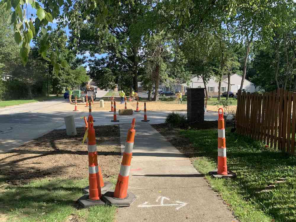
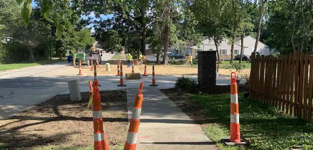
As the driveway apron at the park comes back together, there are plans to continue repairs to the sidewalks, and the remainder of the driveway that was damaged during installation of the connector pipe to Root Ditch. We will be working with the city and the developer to get that work done as soon as possible.
Any residents who would like to contribute ideas to install new landscaping in the entrance to the park can reach out to Jon or Nick via email at board@brettonridge.com .